

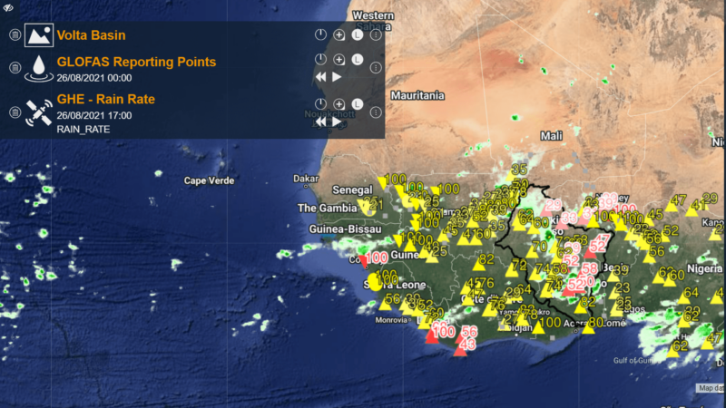
Early warning systems observing rainfall of the 2021 monsoon period (Photo: WMO)
Early warning systems hold the key to disaster management in West Africa
A project funded by the Adaptation Fund and implemented by the World Meteorological Organization (WMO) is improving West African climate adaptation and disaster management by developing region-wide early warning systems.
Specifically, the organisation aims to assist the six countries – Benin, Burkina Faso, Côte d’Ivoire, Ghana, Mali and Togo – that sit above the Volta Basin, ninth largest river basin in sub-Saharan Africa covering an area of about 400,000km2.
The majority of its 29 million inhabitants live below the poverty line, with four of the six ranked among the UN’s list of least developed countries, and livelihoods are highly dependent on agriculture, which is vulnerable to regular extreme meteorological and hydrological events.
“These socio-economic baseline issues are exacerbated by a climate that has undergone considerable change in recent decades and is expected to continue changing throughout the 21st century,” said Ramesh Tripathi, manager of the WMO project.
“Based on an initial assessment with the stakeholders, integrated water resources management, risk maps and development of early warning systems were identified as concrete adaptation measures to increase resilience to floods and droughts and ensure socio-economic sustainable development,” he added.
Through a US$7.92 million grant from the Adaptation Fund, the WMO, alongside the Volta Basin Authority and Global Water Partnership West Africa, is seeking to improve existing flood and drought management strategies and plans at the regional, national and local level.
Since 2019, the project has started developing VOLTALARM, an early warning system for floods and droughts in the region that uses global observational and forecasting products like the Global Flood Awareness System (GloFAS) and data from the likes of the National Oceanic and Atmospheric Administration (NOAA) and the Japan Aerospace Exploration Agency (JAXA).
This, combined with improved risk maps and scenario testing, aims to better understand future climate events and thus more coordinated responses to associated hazards.
Continue reading the original article.