

Mangroves serve as a nature-based solution to reduce flooding risks. Photo Credit: Adaptation Fund
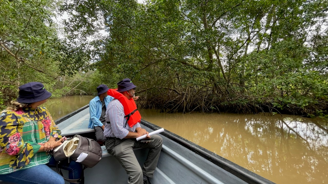
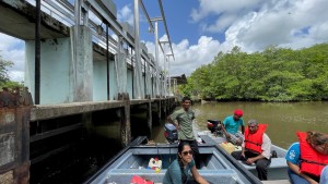
Two pirogue-style fishing boats glide down the South Oropouche River over deep murky water, winding past twisted green mangrove trees looming out from the shallows along both banks.
Caimans sun amid trees, as birds follow the boats’ path. The majestic Scarlet Ibis unique to the Caribbean island’s rich biodiversity flies overhead as the river opens into larger water.
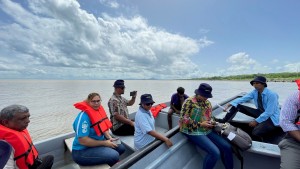
Several partners on a multi-sector adaptation project here in Trinidad have boarded the boats to survey drainage channels, flood control stations and signs of saltwater surges across the South Oropouche River Basin (SORB).
Sea level and floods are on the rise here.
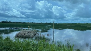
Moderate to severe flooding from brief, high intensity rainstorms occurs regularly and is a perennial issue, but in the last several years larger more devastating basin-wide floods combined with sweeping ocean surges have been happening more often. The time to subside can take several days, affecting farmlands, commercial activities and densely populated residential communities.
Economic losses are mounting. For example a major flood in October 2018 affected about 150,000 people and 4,100 households across the country, according to a report, with 75 percent of local farmers severely impacted through losses of crops and livestock.
“These floods cause major disruption to the productive sector and the populated centers, and frequently result in loss of personal property,” said Anuradha Maharaj-Jagdip, Water and Ecosystems-based Adaptation Specialist of the SORB Project Management Unit, operating through the University of the West Indies (UWI) Engineering Institute, the executing arm of the SORB-Project. “Climate change is expected to increase the frequency and intensity of floods but will also cause sea level rise and augment the occurrence of drier periods resulting in catastrophic impacts especially for the vulnerable populations like the SORB. Climate-induced changes in the marine environment [further] threaten livelihoods such as small-scale fisheries present in the area.”
The shift in climate patterns has led to both extreme droughts during the January-May dry season and extensive flooding during the June-December wet season. “These droughts and floods lead to loss of livelihoods of farmers losing their livestock and crops which they have invested heavily into,” said Daren Sookoo, UWI project coordinator. “Several homes, roads and infrastructure are severely damaged with some instances of loss of human life.”
An Encroaching Sea: ‘It Cuts Your Throat Out’
A small island developing state, Trinidad and Tobago is already vulnerable to significantly rising temperatures, erratic rainfall, sea level rise and hurricanes. The riverine systems along the southwestern coast of Trinidad, the much larger of the two islands, are especially susceptible to increasing climate change impacts – placing ecosystems, infrastructure, burgeoning ecotourism businesses and the modest cottages and docks that line the South Oropouche and surrounding areas at high risk.
The project includes examining policies that also tackle other, non-climatic challenges the area is facing, such as pollution and development around waterways and maintaining and cleaning drainage systems to reduce flooding backups in the basin.
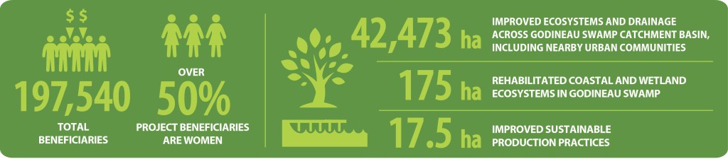
The South Oropouche River flows mostly flat around rolling farmlands through the 3,171-ha Godineau Swamp and out the Gulf of Paria. The swamp receives drainage from a catchment of 42,473 ha that includes small fishers, farmers and nearby urban communities. Some areas already fall below mean sea level. A buffer against flooding and sea level rise, the wetland’s role is essential.
A visible marker of sea level rise is the proliferation of mangroves on the banks of the South Oropouche, extending progressively inland. Scientists recording baseline water measurements note sprouting mangroves and signs of saltwater intrusions further upstream than they had ever imagined previously. “There has been significant saltwater intrusion coming from the Gulf of Paria which has moved about five miles inwards,” Sookoo advised. “This has led to invasion of mangrove species of plants, with traditional crops being in jeopardy of its sustainability.”
Increased salinity in the channels is shaping the project. “Protecting and restoring mangroves is a vital strategy for reducing flood risks in inland areas and for safeguarding the ecosystem goods and services that are essential to the livelihoods and resilience of nearby communities,” Maharaj-Jagdip said.
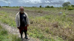
Just inland from the water courses, muddy roads lead to farmlands dotted with seagrass. In between intermittent torrential downpours, local farmers point to their lands with concern of what the future may bring. “We’ve had flooding here, but never to the extent that we have it now,” said local farmer Ramnarine Ramdeo, standing by his approximately 265-acre farm. “Some places didn’t get flooded ever. Now we are getting hit every year, and the losses are becoming bigger and bigger.”
A multi-crop farmer who grows everything from fruits, corn, peas, cucumbers and peppers, Ramdeo said sometimes floods come with little or no warning. “I lost 65 acres last year. It cuts your throat out,” he said. “Flooding has had a devastating impact. You have to consider the tides, too, and water is coming in from multiple sides. Every day is an experience.”
Farmers like Ramdeo are doing what they can to adjust, such as building rows of higher banks for crops with drainage ditches in between and retention ponds nearby.
But as seawater threatens more land, costs are rising. With more unpredictable weather and more acidic soil, crops are dwindling and becoming less sustainable. “The experience we had last year was an eye-opener,” said Ramdeo, citing a flood that brought two feet of water. “It’s the first time in my life that I’ve seen that.”
Science-based Collaboration
The US$ 10 million project funded by the Adaptation Fund and implemented by the Development Bank of Latin America and the Caribbean (CAF) with UWI carries hope to help stem the tide.
It aims to increase resilience of the SORB population and ecosystems to flooding, sea level rise and droughts by strengthening local planning and risk management, water infrastructure, ecosystem-based adaptation, and adaptive capacity of farmers and fishers.
At its core, the project brings together a network of experts and partners on the island from across government, agencies, universities, development banks, NGOs and the farming and fishing communities to thoroughly tackle the problem while taking a scientific approach. “Stakeholder engagement is of paramount importance,” said Sookoo. “Government institutions, first responders, residents, NGOs/CBOs and the use of subject matter experts when collaborating can have a huge and positive impact. All hands on deck are needed to ensure that the most vulnerable are included.”
The project includes flood-risk mapping, land use and water catchment studies, flood level attenuation evaluations, environmental analyses of stormwater from feeder water courses, and ecological, hydrological and socioeconomic impact assessments of the Godineau Swamp.
Study results will help guide ecosystem protections and a community-led ecotourism business plan for the swamp to promote coastal conservation, biodiversity and diversification of resilient livelihoods for farmers and fishers.
With the first couple years of the project focused on gathering baseline studies and increasing hydrometeorological information equipment and networks, other subsequent actions will encompass floodproofing infrastructure and buildings, improving drainage flow systems and flood emergency response plans, as well as enhancing existing floodgates in the canals and adding others at strategic points. River cleaning, structural maintenance and water security will also be strengthened — including recharging aquifers, creating new wells and instituting rainwater harvesting systems to collect and store stormwater for agricultural use.
Determining how far inland saltwater has reached into channels, agricultural and marsh areas will further inform decisions on where saltwater-resistant rice may be needed and which types of crops to plant upstream. Land use impact studies will lead to improved land cover and resilience planning.
Importantly, the project embraces ideas from farmers themselves such as terracing, trenching, crop rotation and climate-resilient crops. Farmers look forward to further practical solutions. “This is a very important and big project,” said Sookoo. “We have huge challenges, but big potential.”
By project’s end, the goal is to have benefited 147,000 direct beneficiaries in the basin and nearly 200,000 people overall. It may not stop there. The hope is that a scalable model emerges beyond its four-year lifecycle. “This is a very beneficial project overall,” said Muhammad Baksh, an engineer of Trinidad’s Drainage Division. “It is like a pilot project, and we will have lessons to be learned for the future.”
“This project is laying a foundation for further projects to come on stream as continuity will be required,” said Daren Sookoo, UWI project coordinator.
As the regional implementing entity of the project, CAF said the combination of territorial planning, green and grey infrastructure, ecosystem restoration, and livelihood diversification will provide tangible relief to communities that have long suffered from recurrent flooding. CAF stressed the importance of its partnerships with the government, UWI and local stakeholders in building a model that addresses urgent challenges in the SORB while offering scalable solutions for other vulnerable areas in the region. “At CAF we believe that adaptation efforts are strongest when they combine infrastructure, nature-based solutions, and community engagement. This project in Trinidad and Tobago shows how regional cooperation and local ownership can deliver real impact—reducing flood risks, protecting ecosystems, and improving livelihoods. We are committed to continue working hand in hand with our partners and the Adaptation Fund to scale up these solutions across the Caribbean,” said Sebastián Rodríguez Claros, CAF’s principal executive for adaptation and resilience.
Digital Platform and Youth Engagement as Game-changers
Disaster preparedness will improve on several levels.
Project studies and secondary data from local agencies will assess rainfall patterns, temperature projections and climate change forecasts. Water meters will be installed in at-risk communities to enhance water management. Communities’ flood responses will be strengthened by widely circulating manuals and sensitization exercises that help households build climate resilience.

Hydrometeorological and tidal networks will be enhanced to make data available for informed decision-making at multiple governance levels. Tracking sea level changes and tidal effects on flooding will provide information for early warning systems to be put in place.
Software called the River Course Information Management System (RIMS) is being developed to facilitate a more coordinated and timely response to drainage maintenance and accountability.
Despite challenges such as new development appearing near some drainage pathways, stakeholders are determined to make a positive impact. “With RIMS and other flood models, we can map all of this and produce expected impacts as close to reality as possible to assist decision-makers,” said Maharaj-Jagdip. “This shows the combined changes, natural and manmade and their effects. The increasing climate challenges and their impact on flood frequency and intensity must be carefully forecasted at the highest resolution possible.”
Perhaps the project’s biggest hope lies with the island’s next generations. It has multiple components that involve and empower youth, with the aim of extending its knowledge and impacts across years to come.
It raises awareness of adaptation among youth, empowers women and girls, builds local capacities and mobilizes resilient actions. It promotes learning of both climate impacts and solutions through community awareness campaigns and public education programs.
At least 100 schools have been involved in site visits and field trips. “Children are key players in disseminating climate change information and technologies,” said Maharaj-Jagdip. “Part of the sustainability strategy is to improve the knowledge and develop resources on local climate change risks related to flooding, saline intrusion and droughts, as well as appropriate adaptation solutions in local schools so teachers can roll it out in their classes, developing an affinity in students for the reality of climate change [and actions they can take] in their neighborhoods — generating a multiplier effect.”
The ultimate aim is to build resilience from within.
Explore additional photos in the Flickr album.
View a video on this project here.
For media inquiries, please contact:
Mr. Matthew Pueschel
Adaptation Fund Communications
mpueschel@adaptation-fund.org